The Sedimentary Basin Concept
The sedimentary layers at
the earth's surface overlie a complex of igneous & metamorphic rocks that,
in continental areas, we call basement
(Fig 1).
A sedimentary basin occupies a depression in the basement surface. Geologists
usually use the term basin to include both the depression itself and the
thicker-than-average sediments that fill it..

In contrast to basins,
areas that receive a normal veneer of sediment over the basement are called platforms or shelves (Fig 2).
Arches, which are located over
regional basement uplifts, receive thinner-than-average sediment. Arches have
persistent regional positive relief, platforms neutral relief, & basins
negative relief with respect to their surroundings. However, these terms are
defined without reference to topography, & a sedimentary basin need not be
a marked topographic basin. It can occur as part of a mountain chain, on
continental peneplains or in ocean areas. Conversely, a present-day deep ocean
basin is not necessarily a sedimentary basin, since many are floored by igneous
rock with only a veneer of sediment. Basins often change through time, & can
undergo several distinct stages. They can evolve from one basin type into
another. They can also develop in areas that were originally shelves &
arches.
Geometry of Sedimentary Basins
With regard to geometry,
basins vary widely in both size & shape. They usually cover an area of at
least 1000 km2, but some of the world's largest basins have areas of
several million square kilometers. Maximum sediment thickness, at a basin's
depocenter, usually exceeds 2 or 3 km & can reach over 10 km in some cases.
Some basins are circular or elliptical in map view. Others appear rectangular &
trough-like. Some basins are actually embayments that open out into larger sediment-
tary basins & lack closure. A basin can be symmetrical or asymmetrical in x-sect
profile, or it can have an irregular profile.

It is tempting to
believe that a sedimentary basin was deepest where its sediments are thickest,
but this is not necessarily true. An example of this is a basin that received
land-derived sediments from a single source direction, as in a delta (Fig 3), Non-coincidence of
depocenters, topo-graphic low & point of maximum basement subsidence in a
land-derived, prograding
clastic wedge).
In this case, the depocenter of a sedimentary unit will initially be adjacent
to the basin margin, & sediments will thin seaward.
In time, the depocenter
migrates laterally away from the basin margin, toward the topo-graphic low,
where water depth is greatest. At any one time, the basin's depocenter, the
point of maximum basement subsidence, & the topographic low will probably
not coincide. Similarly in carbonate basins, most deposition takes place along
the shallow shelf margins, where organisms thrive in well-oxygenated,
nutrient-rich conditions. Reefs & skeletal carbonate sands thin both toward
the basin margin & toward the condensed lime mud sequences of the deeper
basin.
Sediment Fill
Basins can be characterized
by the sediments that fill them. They can be dominated by continental, shallow
marine, or deep marine sediments, depending on their elevation & the
interplay between the rate of subsidence & the rate of sedimentation. Most
sedimentary basins show that subsidence & deposition took place at about
the same time. If sedimentation keeps pace with subsidence in a marine basin,
no unfilled void ever exists, & the basin will be filled with shallow-water
sediments. At the other extreme, initial subsidence can produce a deep void
that is later filled. This can produce some secondary isostatic subsidence as a
result of sediment load.
Basins that develop far
from terrigenous sources of sediment, or are isolated from them by to pographic
barriers or sills, may contain abundant carbonates or evaporites, depending on
the paleo-climate. They may also be starved basins, filled mainly with water &
receiving very little sediment.
Tectonic Processes & Timing
An important aspect of
sedimentary basins is the nature and timing of tectonic processes. The types of
folds & faults that develop within a basin are partly due to deformation
mechanisms & partly to its sediments. Deformation by compression commonly
produces folds & thrust faults; extension leads to normal & block
faulting. However, the presence of such features as salt domes & growth
faults is largely dependent on the nature & thickness of the basin's
sediment fill.
When considering the
generation, migration, & accumulation of petroleum, the timing of
structural growth is very important. Petroleum accumulation is often favored by
active structural deformation during sedimentation, which leads to rapid
changes in sediment facies & thickness. Organic-rich shales can be
deposited in deep, structurally low areas, while coarser-grained reservoir
facies & combination traps can develop over structural highs.
Unconformities & faults are often present to assist migration processes.
When sediments both
accumulate & are folded at the same time, anticlines may change in shape &
amplitude & their crests may shift laterally with time as they grow. This
can make it dif-ficult to decide just where to drill to locate an oil pool.
Problems of this kind have been encountered in petroleum exploration in the
Northwest Desert of Egypt (Metwalli et al., 1979).
Structural deformation
which occurs at a late stage of basin sedimentation can also assist the
generation of oil, since it may be accompanied by higher-than-average heat
flow. Such basins are often called structural
basins, because they have acquired their present basin architecture
after deposition has ceased. This is often indicated by the presence of facies &
paleocurrent directions which are discordant & not concentric with the
basin's outline. These basins will tend to have pure structural traps. However,
if any structures are formed after petroleum generation and migration have
ceased, they may well be barren.
Extreme tectonics following
basin development can produce adverse effects. If defor-mation elevates the
reservoir rocks to the near-surface, ground water invasion or erosion can
occur, & with it, the degradation or loss of oil & gas. In contrast,
high heat flow & deep tectonic burial of reservoir rocks can cause
metamorphism & over-maturation of hydrocarbons.
Basin-Forming Mechanisms
Basins form as a result of
large-scale vertical & horizontal movements within the earth's upper
layers, which can be explained through the widely accepted theory of plate
tectonics. The location of basins with respect to the earth's plates,
therefore, is fundamental to classification. A detailed treatment of this topic
is beyond the scope of this discussion, but further details will be found in
references such as Fischer & Judson (1975), Seyfert & Sirkin (1973) &
Davies & Runcorn (1980). The basic concepts of plate tectonics, as it
relates to sedimentary basin formation, may be briefly stated as follows.

The earth's outermost shell
is a rigid layer called the lithosphere, which consists of crust & upper- most
mantle. Topographic lows form on the earth's surface where the crust is thin, &
composed of dense basaltic rocks Fig 4, The earth's outermost
layers. Oceans occupy these topographic lows, & so this dense crust
is called ocean crust. On the other hand, continental crust is thick, composed
of lighter, granitic rocks, & is, therefore, topographically higher than
ocean crust. Sedimentary basins form either on continental crust or on
intermediate crust. Intermediate crust occurs at the boundary between ocean &
continental crust & is transitional between them.
The rigid lithosphere
overlies a less viscous layer called the asthenosphere. Convection in the asthe-
nosphere causes the rigid lithosphere to break apart into plates that move
slowly across the earth's surface with respect to one another. There are about
eight major, well-defined plates on the earth's surface today. Fig 5,
distribution of lithospheric plates,
showing relative velocity & direction of plate separation & convergence
in centimeters per year, as well as many smaller microplates whose
details are somewhat less clear. The interiors of plates are relatively stable,
but their edges are tectonically active.
Plates break apart, or
diverge, at mid-ocean ridges, as basalt upwells from the mantle to form new
ocean crust and the sea floor spreads laterally. The forces involved are mainly
extensional, & the process begins over continental crust.

Divergence is initiated by
upwelling convection currents, which produce a dome-like bulge in the crust Fig 6a, Initiation of rifting &
ocean floor spreading over continental crust. When forces become too
great, this bulge rifts in a radial pattern, usually with three branches (Fig 6b). As plate separation takes place, only two arms of the rift
actually continue to spread. They connect up with two arms of other triple
rifts, and eventually become a small ocean basin. The third arm stops opening,
and becomes a failed rift (Fig 6c).
A modern example of this is the Red Sea & Gulf of Aden, which are an
incipient ocean basin involving two rift branches, thus causing Africa to move
away from Arabia. The long East African rift valley is being left behind as a
failed third arm. Fig 7, Red Sea, Gulf of Aden, East
Africa rift, shown as faulted grabens in the center of the uplifted &broken
Nubian-Arabian shield. As the sea floor continues to spread, new ocean
crust is added only at the axial zone, where a mid-ocean ridge begins to form.
The separated continents are now far apart, & basins develop along their
passive margins (Fig 8,
Model of a diverging plate boundary,
showing the basins that develop along the passive margins of the continents).
This configuration is analogous to the Atlantic ocean margins of today.
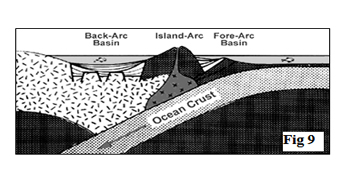


Where plates come together
or converge, the dominant forces are compressional. At a subduc tion z, the
leading edge of one plate overrides another, & the overridden plate is
dragged down into the mantle & consumed (Fig 9,
Mo del of a subducting plate margin,
showing ma jor tectonic elements & associated basins). Island-arcs
can be created by volcanism mixing of continental ocean crusts near a
subduction zone
Fig 11 , Model of a collisional plate margin, showing contintent- continent
collision). The narrow linear zones of continent-continent or
arc-continent collisions have frequently been called sutures. Small, complex
basins form adjacent to mountain uplifts & along tectonic sutures in both
of these situations.
In summary, there are 3 fundamental types of plate boundaries: 1)
Mid-ocean ridges, 2) Subduction zones & sutures, & 3) Transcurrent faults.

Basins are created along
the passive margins of pulled apart continents & along the less successful
failed arms of triple rifts. Basins are also created along active con-vergent
continental margins, where subduction, continental suturing or transcurrent
faulting takes place.
Finally, there is a third
group of basins that are found within the stable interiors of plates &
whose origin may be less closely linked to plate tectonic processes.
Sedimentary
Basin Classification

Over the years, many
different basin classification schemes have been proposed, as geological
thought has evolved from the geo-syncline concept to plate tectonics. However,
in the petroleum industry, a classification is needed that emphasizes the role
of the sedimentary basin as a container for oil & gas.
This is particularly
important since more than a third of the world's basins can still be considered
frontier basins when it comes to petroleum exploration. If we can find ways to
group known petroleum ba- sins that have common oil & gas charac- teristics,
we can relate this data to look-alike basins, with unknown petroleum prospects
or areas that have not been fully developed.
The basin classification
presented here combines the schemes of both Huff (1978, 1980) & Klemme
(1980) Fig 13.
It is similar to many such schemes that are widely used in the industry. There
are a total of ten basin types: two that are related to stable continental
plates; two that develop through plate divergence; & four that relate to
plate convergence. Two other types, basins that downwarp into small oceans,
form a separate class because of their unique petroleum features.
These downwarp basins are
associated with either small spreading, or small shrinking seas. Tertiary-age
deltas are overprints superimposed onto sedimentary basins belonging to other
basin types. Other basin classification schemes include those of Bally &
Snelson (1980), Uspenskaya (1967) & Perrodon (1971).
Of course, all basins are
to some extent unique & they do not necessarily fit neatly into such
categories. Not all geologists will agree when it comes to assigning a
particular basin to a particular class. For example the Sverdrup basin of the
Canadian arctic has been variously assigned to the interior basin (Huff, 1980) &
opening downwarp classes (Bally & Snelson, 1980; Klemme, 1980).
Exercise 1. Give one example in which a basin's depocenter, its
topographic low point, and its point of maximum basement subsidence will not,
in all likelihood, coincide.
Solution
A basin that receives land-derived sediments from a
single source direction. An example is a delta (or any other seaward
prograding, clastic wedge)
A carbonate-rich basin. Typically deposition is at a
maximum along shallow shelf margins, where shelly organisms thrive in greatest
abundance
Exercise 2. Relate the following
features to either convergent or divergent plate tectonic processes:
A.
____________ upwelling in the asthenosphere.
B.
____________ suture zone.
C.
____________ failed arm rift.
D.
____________ large-scale transcurrent (strike-slip) fault motion.
E.
____________ active continental margin.
F.
____________ passive continental margin.
Solution
Relate
the following features to either convergent or divergent plate tectonic
processes:
A.
Divergent upwelling in the asthenosphere.
B.
Convergent suture zone.
C.
Divergent failed arm rift.
D.
Convergent large-scale transcurrent (strike-slip) fault motion.
E.
Convergent active continental margin.
F. Divergent passive continental margin.
Exercise 3. What is the sequence of
events which leads to the development of a new ocean basin and the splitting
apart of continents?
Solution
Upwelling convection in the asthenosphere produces a
dome-like bulge in the continental crust. This bulge splits in a radial
pattern, usually with three branches.
Two arms of the rift connect up with two arms of other
rifts, and they continue to spread as basaltic ocean crust is added. These
become a new ocean basin. & The
failed third arm becomes dormant.
Tidak ada komentar:
Posting Komentar